Introduction
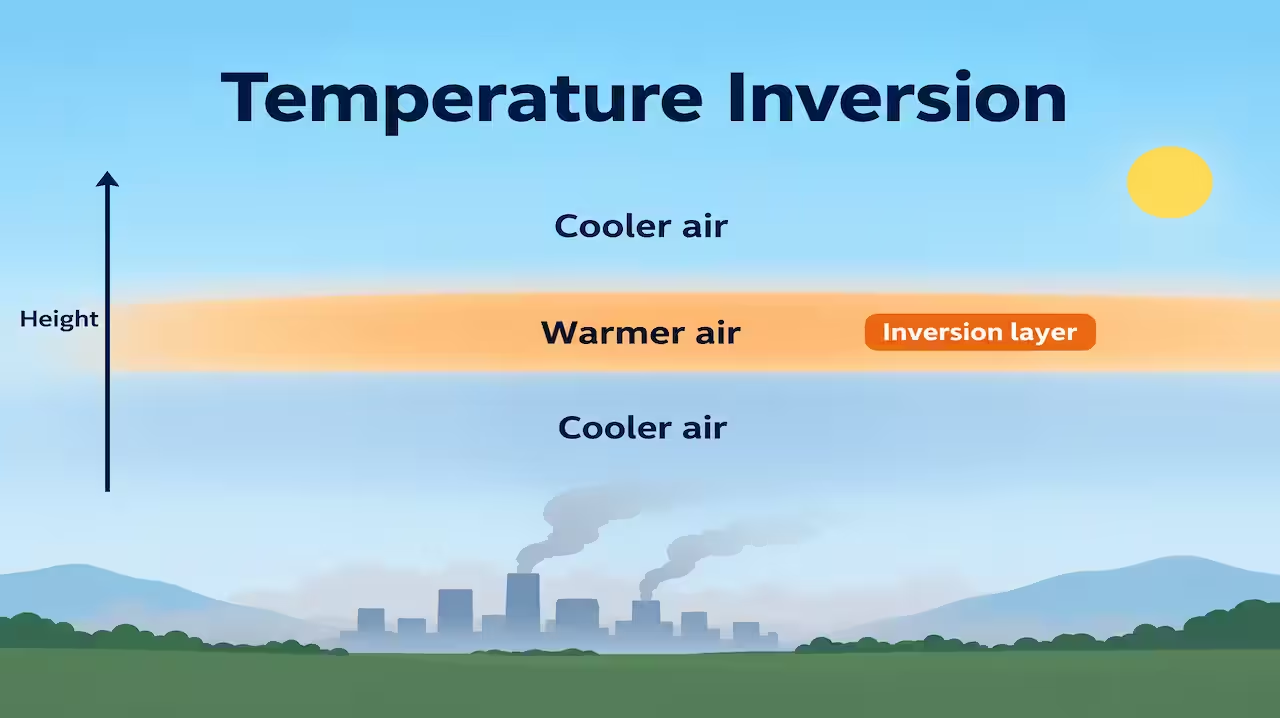
In the troposphere we are taught a simple rule: as you go up, it gets colder. That is the normal lapse rate. On some days and nights the rule breaks. A layer of air is warmer than the air below it. Temperature rises with height for a while. That upside-down layer is a temperature inversion.
The correct heading is temperature inversion (sometimes thermal inversion). “Temp inversion” is only a short form.
I used to skip this page because it sounded like a small exception. It is not small. Inversions decide whether fog will sit on a runway, whether smoke will hang over a city, whether frost will kill a crop, and whether a pilot will meet a sudden change in air. Winter Delhi’s bad air, valley fog, and the “lid” over a high-pressure sky all sit in this topic.
If normal air is a ladder that cools as you climb, an inversion is a warm floor above a cold room. Smoke and moisture get trapped under that floor.
What temperature inversion means
Lapse rate is the rate at which temperature changes with height. The average environmental lapse rate in the troposphere is about 6.5°C per kilometre (roughly 3.5°F per 1,000 feet). Temperature usually falls as altitude rises.
In an inversion, in a certain layer, temperature increases with height, or at least stops falling. The layer where this happens is the inversion layer. Above or below it, the normal fall of temperature may return.
The air under a strong inversion is stable. A parcel that tries to rise finds itself colder and heavier than its surroundings, so it sinks back. Vertical mixing is weak. That is why pollution and fog love inversions.
Memory:
Normal = colder up. Inversion = warmer up (in that layer). Stable lid.
Why the normal rule exists at all
The ground and lower air are heated mainly from the surface. The Sun warms land and sea; they warm the air. Higher up, air is farther from that heat source and expands as pressure falls, so it cools. That is the everyday story of the troposphere.
An inversion appears when that pattern is disturbed: the ground cools very fast, or air sinks and warms from above, or a warm air mass rides over a cold one.
Main types of temperature inversion
Textbooks group inversions by how they form. Names vary a little, but these are the ones that matter.
1. Radiation inversion (surface / ground inversion)
How it forms
On a clear, calm night the ground loses heat by long-wave radiation. The air touching the ground cools. Air a few tens or hundreds of metres up stays warmer for longer. Temperature then increases from the cold surface upward into that warmer layer.
Clouds act like a blanket; wind mixes the air. So radiation inversions need clear sky and light wind. Long winter nights help. Dry air also helps because moisture holds heat better.
Where and when
Winter nights over continents. North Indian plains in December–January. Rural fields more than busy city centres at first, though cities can have their own patterns. Valleys collect cold air and strengthen the effect.
What follows
Radiation fog when moisture is enough. Frost on crops when the surface goes below freezing. Smoke from evening fires sits in a thin layer. Morning sun usually weakens this inversion; by late morning the ground warms and the lid often breaks.
Memory:
Night, clear, calm → ground freezes the air → warm air sits on top.
This is the most common inversion people feel without knowing the name.
2. Subsidence inversion
How it forms
In a high-pressure area, air sinks from aloft. Sinking air is compressed and warms. A warm layer forms above cooler air nearer the surface. The inversion can sit from a few hundred metres to one or two kilometres up, not only at the ground.
Where and when
Subtropical highs. Persistent winter anticyclones. West coasts under sinking air, such as parts of California, can have strong subsidence inversions. Over India, winter western highs and quiet high-pressure spells can contribute to a raised lid that traps haze.
What follows
A stable “ceiling.” Fair weather at the surface sometimes, but dirty air if cities pump smoke under the lid. Cloud tops may flatten under the inversion. Flying through the layer can mean a sharp temperature jump.
Memory:
High pressure = sinking = warming from above = lid.
3. Frontal inversion
How it forms
At a front, warm air overlies cold air. Along a warm front, warm air climbs over a cold wedge. The boundary is a sloping zone where temperature can increase with height through that zone. Cold fronts have their own structure, but the idea is the same: two air masses stacked, warm over cold in part of the column.
Where
Mid-latitude fronts. Western disturbances affecting north India in winter can bring frontal structures and layered cloud. Europe and North America see this often in textbooks with cross-section diagrams.
What follows
Cloud bands, steady rain or snow with warm fronts, changes in wind and temperature. The inversion is one slice of the frontal package, not a calm night story.

Memory:
Warm air on cold air at a front = ready-made inversion.
4. Advection inversion
How it forms
Warm air moves horizontally over a cold surface — cold land, snow, or a cold sea current. The bottom of the warm air cools. A temperature increase with height develops in the lower layer.
Where
Warm air over a snow field. Sea fog regions where mild air drifts over cold water. Some coastal and polar-margin cases.
Memory:
Warm wind over a cold floor → bottom cools → inversion.
5. Valley inversion (and related cold-air drainage)
How it forms
At night, cold dense air drains down slopes into the valley floor (katabatic drainage). The valley bottom becomes a pool of cold air. Warmer air sits above the pool. Hillsides may stay milder than the valley floor — a classic frost pocket.
Where
Himalayan valleys, hill stations’ lower bowls, any mountain basin on a clear night. Fruit growers know the valley floor can freeze when the slope does not.
Memory:
Cold air runs downhill and fills the bowl; warm air is the lid.
This often works together with radiation cooling. Many “valley inversions” are radiation inversions shaped by terrain.
6. Marine / coastal patterns (linked types)
Cool sea, warm land, or the opposite, plus subsidence aloft, can stack stable layers. California’s persistent inversion and fog is a famous combination of cool marine air and sinking air aloft. You need not invent a new genus; place it under advection + subsidence when you write.
Inversion and atmospheric stability
Stability is the heart of the topic for exams.
- Unstable air: parcel rises and keeps rising → towers, showers, mixing.
- Stable air: parcel is pushed up and falls back → sheet clouds, fog, trapped smoke.
- Inversion: a strong form of stability in that layer.
A surface inversion stops vertical mixing near the ground. Pollution from cars, stubble burning, industries and kitchens stays near breathing height. That is why a calm winter morning in a big city can look and feel worse than a windy afternoon with the same emissions.
Upper inversions act like a lid on convection. Cumulus may form below but cannot grow through the warm layer. Storm forecasts care about where the inversion sits and how strong it is.
Related effects you should always connect
Fog and mist
Radiation inversion + enough moisture → radiation fog. Common after midnight into early morning. Visibility falls. Roads and airports suffer. Sun or wind later may clear it.
Advection fog when mild moist air moves over a cold surface is related to advection inversion ideas.
Frost
On clear winter nights the ground can fall below 0°C while a thermometer at head height reads higher. Ground frost damages tender crops. Valley floors are worst. Farmers use fans, irrigation, or smudge pots in some regions to mix or protect — the principle is breaking or softening the cold pool.
Air pollution and smog
Inversion traps pollutants. Classic London-type smog needed cold stable air plus smoke. Today’s winter haze in parts of north India is a mix of emissions, low wind, moisture, and frequent surface inversions. The inversion does not create the pollution; it stops it from escaping.
Flying and visibility
Pilots meet a temperature jump at the inversion top. Visibility may change sharply. Fog under a surface inversion is an operational hazard. Icing and haze layers also relate to stable stratified air.
Sound and radio (extra, short)
Sometimes sound carries farther under an inversion because waves bend back toward the ground. A distant train sounds near. This is a side note, not the core of GS answers.
Diurnal cycle
Surface radiation inversions form at night and weaken after sunrise. That daily rhythm is why many cities feel cleaner by afternoon on the same emission day, if the sun and wind win.
Where it appears in Indian geography answers
- Winter north India: long nights, clear spells, ground inversions, fog on highways, delayed flights, crop frost in pockets, and pollution episodes when winds are light.
- Himalayan valleys: cold air drainage, frost hollows.
- Western disturbances: frontal cloud and rain/snow; inversions as part of frontal structure, not the only story.
- Anticyclonic winter spells: subsidence contribution to a stable lid.
Link inversion to climatic hazards and environmental geography, not only to a definition.
How to read a diagram
Exam figures often show height on the vertical axis and temperature on the horizontal.
- A line sloping so that temperature falls with height = normal.
- A line bending so that temperature rises with height = inversion layer.
- Surface inversion starts at the ground.
- Elevated inversion has normal or mixed air below and the warm lid above.
If smoke is drawn, it spreads sideways under the lid instead of rising in a plume.
Comparison with normal conditions
| Feature | Normal troposphere | Under inversion |
|---|---|---|
| Temperature with height | Generally decreases | Increases in the layer |
| Vertical mixing | Easier when unstable | Suppressed |
| Visibility | Often better with mixing | Fog / haze common |
| Pollution | Can disperse upward | Traps near surface |
| Cloud form | May grow tall if unstable | Sheet, fog, flat tops |
| Typical time | Day heating | Night radiation; also highs and fronts |
How I remember the types
Four doors:
- Night ground cools → radiation inversion
- Air sinks in a high → subsidence inversion
- Warm air climbs over cold → frontal inversion
- Warm air moves over cold ground/sea → advection inversion
Terrain twist:

- Cold air pools in a valley → valley inversion
One line:
Warm over cold is the shared idea; only the reason changes.
Common mistakes
Writing that inversion means the whole troposphere is upside down. It is usually a layer.
Saying inversion causes pollution. It traps pollution that already exists.
Mixing inversion with “greenhouse effect.” Greenhouse is about outgoing radiation and gases. Inversion is a temperature profile with height.
Claiming every fog is an inversion story without moisture and cooling. You need both.
Forgetting that daytime heating often destroys a weak surface inversion.
Giving only London smog and ignoring Indian winter fog and haze.
How to write it in the exam
2 marks: Temperature inversion is a layer in which temperature increases with height instead of decreasing; it makes air stable and can trap fog and pollution.
5 marks: Define. Explain radiation inversion with clear calm night. Mention one more type (subsidence or frontal). One effect: fog or pollution.
10–15 marks: Define and contrast with normal lapse rate. Types with formation. Stability. Effects on weather, crops, transport, cities. Indian winter example. A simple height–temperature sketch.
For disaster or environment papers, stress health and transport under prolonged urban inversions.
A walk through one winter night
Sunset. Sky clear. Wind dies. Ground radiates heat to space. Grass cools. Air at your shoes cools. Air at the roof of a two-storey house is still milder. An inversion has begun.
Smoke from a fire goes up a little, then flattens. Distant lights look soft. If moisture is high, fog nucleates in the cold layer. By dawn the world is white and the highway is slow. After sunrise the ground warms, parcels mix, and the lid weakens. By noon the “exception” may be gone.
That single night contains definition, type, effect and diurnal break. If you can narrate it, you understand the topic.
Conclusion
Temperature inversion is a temporary reversal of the usual fall of temperature with height. A warm layer sits over colder air. The air below becomes stable. Fog, frost, haze and flat smoke plumes are the everyday signatures.
Radiation inversions write the clear winter night. Subsidence inversions write the high-pressure lid. Fronts and advection write their own stacks of warm over cold. Valleys collect the coldest air at the bottom.
The normal atmosphere cools upward. An inversion is the exception that explains why some mornings feel trapped. Once you see the warm lid, the rest of the chapter — stability, fog, smog, frost — sits in place.
FAQs
Q1. What is temperature inversion?
A: It is a condition in which temperature increases with height in a layer of the atmosphere, opposite to the usual decrease in the troposphere.
Q2. What are the main types of temperature inversion?
A: Radiation (surface) inversion, subsidence inversion, frontal inversion, advection inversion, and valley inversions linked to cold-air drainage. Combinations are common.
Q3. How does a radiation inversion form?
A: On a clear, calm night the ground loses heat rapidly. The lowest air cools while air above stays warmer, so temperature rises with height near the surface.
Q4. Why is inversion linked to pollution?
A: Stable air under an inversion stops vertical mixing, so smoke and other pollutants stay near the ground instead of dispersing upward.
Q5. Does inversion only happen in winter?
A: Surface radiation inversions are strongest on long, clear nights, so winter is classic, but inversions can form in other seasons wherever the right cooling, sinking, or frontal stacking occurs.