Introduction
The ocean is not still water. Great rivers of seawater move through it, some warm, some cold, some at the surface, some in the deep. These are ocean currents.
They matter because they move heat around the planet. Western Europe stays milder than places at the same latitude in Canada partly because of warm water from the south. Deserts sit on some western coasts partly because cold water chills the air above them. Fish gather where cold water rises and brings food. Ships once planned routes around these flows; climate still does.
In school geography this is a map chapter and a climate chapter at once. If you only memorise names on a blank ocean, you forget them by the next paper. If you learn why water turns and what warm or cold water does to the air above, the map sticks.
What an ocean current is
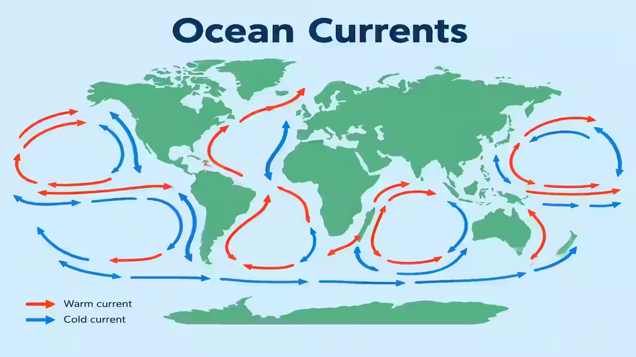
An ocean current is a continuous, directed movement of seawater. It can be driven mainly by wind at the surface or by differences in density (temperature and salt) in the deep. Surface currents are the ones drawn on most atlas maps. Deep currents are slower and complete the global “conveyor.”
Speed is usually modest compared with wind — often a few kilometres per hour — but the volume of water is enormous. A slow giant still moves more heat than a fast trickle.
Currents are named mostly by direction or region: Gulf Stream, Kuroshio, Benguela, Labrador, Agulhas. Warm currents generally move water from lower latitudes toward higher latitudes. Cold currents generally move water from higher latitudes toward lower latitudes, or carry cold upwelled water along a coast.
Memory:
Warm current = tropical water on a poleward trip. Cold current = polar or upwelled water on an equatorward or coastal trip.
What makes currents move
Several forces work together. No single cause explains every map.
1. Planetary winds
Trade winds push surface water westward near the tropics. Westerlies push water eastward in the middle latitudes. That is why subtropical oceans develop large loops. Wind is the main driver of the broad surface pattern you draw in exams.
2. Coriolis force
Earth’s rotation turns moving water — to the right in the Northern Hemisphere, to the left in the Southern Hemisphere. So the wind-driven flow does not go in a straight line. It curves and helps build circular gyres.
3. Shape of continents and ocean basins
Continents block and steer. Water piles against a coast and then has to go north or south. The narrow shape of the Atlantic, the open Southern Ocean, and the island arcs of the Pacific all shape the routes.
4. Density differences (thermohaline)
Cold water is denser. Very salty water is denser. In the North Atlantic, cold salty water can sink and feed deep return flow. This is the slow thermohaline circulation or global conveyor idea. It links surface and deep ocean over centuries of path length, though local sinks are continuous.
5. Temperature, salinity and seasonal change
Heating, cooling, monsoon winds, and freshwater from rivers or ice all tweak density and seasonal surface flow. The Indian Ocean is the classic monsoon-reordered basin.
6. Gravity and sea-surface slope
When wind piles water against a coast, the surface slopes. Water flows away from the pile. Geostrophic balance (pressure gradient and Coriolis) helps set the steady current in the open ocean.
For most GS answers, lead with wind + Coriolis + continents, then add density for the deep conveyor and monsoon for the Indian Ocean.
Warm currents and cold currents
This is the classification exams love.
Warm currents
- Bring relatively warm water into cooler regions
- Often flow on the western sides of subtropical ocean basins (western boundary currents) — strong and narrow
- Raise air temperature and moisture above them
- Can increase rainfall on nearby windward coasts when other conditions allow
- Examples: Gulf Stream, Kuroshio, Brazil Current, Agulhas, East Australian Current
Cold currents
- Bring relatively cold water into warmer regions
- Often found on the eastern sides of subtropical basins
- Cool the air, reduce evaporation, and help create arid west coasts
- Linked with upwelling and rich fisheries in many places
- Examples: California Current, Canary Current, Benguela, Peru (Humboldt), Labrador, Oyashio
Rule of thumb for subtropical gyres:
West side warm and strong. East side cold and broad.
That one line places half the map.
Ocean gyres: the big picture
In each major ocean basin, surface flow forms a large loop.
Northern Hemisphere subtropical gyres turn clockwise.
Southern Hemisphere subtropical gyres turn anticlockwise.
A typical North Atlantic loop, said simply:
- North Equatorial Current (westward under trades)
- Gulf Stream / North Atlantic Drift (north and east)
- Canary Current (southward, cooler)
- back into the tropical westward flow
Pacific and South Atlantic have matching logic with different names.
Around Antarctica, the Antarctic Circumpolar Current runs east with the westerlies, uninterrupted by continents. It is the great eastward belt of the Southern Ocean.
Near the equator, westward trades drive Equatorial Currents. Between them, a weaker Equatorial Counter Current can flow east. Know that these exist; do not over-detail every branch unless asked.
Major currents by ocean (exam map set)
Atlantic
| Current | Warm / Cold | Role in one line |
|---|---|---|
| Gulf Stream | Warm | Strong western boundary flow off North America |
| North Atlantic Drift | Warm | Extends heat toward Europe |
| Labrador Current | Cold | South from Arctic; meets Gulf Stream; fog banks |
| Canary Current | Cold | East Atlantic, cools NW Africa coast |
| Brazil Current | Warm | South Atlantic western side |
| Benguela Current | Cold | SW Africa; upwelling and dry coast |
Meeting of Labrador (cold) and Gulf Stream (warm) helps the famous fog off Newfoundland. Icebergs can drift on the cold side — Titanic geography in one sentence.
Pacific
| Current | Warm / Cold | Role in one line |
|---|---|---|
| Kuroshio | Warm | Asia’s “Gulf Stream” off Japan |
| Oyashio | Cold | From the north; meets Kuroshio |
| California Current | Cold | East Pacific; cool dry influence on US west coast |
| Peru / Humboldt Current | Cold | South America west coast; upwelling; rich fish |
| East Australian Current | Warm | Western side of South Pacific gyre |
Peru Current + upwelling = classic cold-coast desert (Atacama) and anchovy fisheries. When that system falters in El Niño years, water warms, upwelling weakens, and climate and fish shift. One paragraph of that link is enough for most papers.
Indian Ocean
The Indian Ocean is special because monsoon winds reverse.
- In the northern Indian Ocean, currents can reverse with summer and winter monsoon.
- Somali Current becomes strong in summer and is linked with intense upwelling off Somalia.
- Agulhas Current (warm) flows south along Mozambique / South Africa’s east side.
- West Australian Current (cool influence) sits on the eastern side of the basin’s south.
- Mozambique Current and branches feed the Agulhas system.
For India: southwest monsoon winds over a warm Arabian Sea and Bay of Bengal are the climate story; ocean currents support heat and moisture patterns but the monsoon is not “caused only by one named current.” Keep monsoon and currents connected, not confused.
Southern Ocean
Antarctic Circumpolar Current (ACC) — eastward, cold, continuous. Isolates Antarctica and helps keep it frigid.
Upwelling: the vertical partner of surface flow
When wind drives surface water away from a coast, deeper water rises to replace it. That rising water is cold and nutrient-rich. Plankton bloom. Fish follow.
Famous upwelling coasts: Peru, California, Benguela (Namibia/Angola), Somalia in summer, parts of the Canary system.
Cold current and upwelling often sit together on eastern ocean boundaries. That is why “cold current = desert coast + good fishery” is a repeated exam pair — true in many cases, not every coastline on Earth.
Memory:
Wind pushes surface water offshore → deep water up → cold, food-rich, dry air above.
Effects of ocean currents (write these in answers)
1. Climate and temperature
Warm currents raise coastal temperatures in higher latitudes (northwest Europe vs same-latitude Canada). Cold currents lower temperatures on tropical west coasts.
2. Rainfall and deserts
Cold water → cooler, more stable air → less evaporation and less rain → coastal deserts (Atacama, Namib, parts of western Australia). Warm currents can feed moisture into onshore winds where geography allows.
3. Fog
Warm air over a cold current (or cold air over a warm current) can make fog. Newfoundland, California coast, and some upwelling shores are examples.
4. Fishing
Upwelling zones are among the world’s richest marine fisheries.
5. Navigation
Historical sailing routes used or avoided currents. Modern shipping still accounts for them in fuel and time.
6. Sea ice and icebergs
Cold currents can carry ice into shipping lanes.
7. Climate variability
El Niño / La Niña involve changes in Pacific equatorial currents, upwelling, and atmosphere. Mention as a link, not a full second chapter, unless asked.
Thermohaline circulation in plain words
Surface maps are not the whole ocean. In the North Atlantic, water becomes cold and salty enough to sink. Deep water spreads. Elsewhere, water returns toward the surface. The full loop is slow and global. School answers call it the great ocean conveyor or thermohaline circulation.
You need not draw every deep branch. You need: density-driven deep flow complements wind-driven surface flow.
If the North Atlantic sinking weakened strongly in a climate story, Europe’s mildness could be affected over long timescales. That is a discussion point in advanced essays, not a one-line dogma.
How to read the world map for marks
- Find the subtropical gyre.
- Western boundary → warm, strong (Gulf Stream, Kuroshio, Brazil, East Australian).
- Eastern boundary → cold, upwelling-prone (Canary, California, Peru, Benguela).
- High latitude east coast of North America / Asia → cold currents from the pole (Labrador, Oyashio).
- Southern Ocean → ACC eastward.
- North Indian Ocean → monsoon reverses seasonal arrows.
Draw arrows in pencil first. Label warm in red pencil and cold in blue if the paper allows colour logic in practice notes.
Indian exam favourites (keep ready)
- Gulf Stream and North Atlantic Drift → mild western Europe
- Labrador Current → cold + fog, contrast with Europe
- Peru / Humboldt Current → Atacama + fisheries + El Niño link
- Benguela → Namib
- Western Ghats rain is monsoon + orography, not an ocean current name; do not force currents into every Indian rain answer
- Somali upwelling in northern summer
- Agulhas Current as warm western boundary of the South Indian Ocean
How I remember
Gyre spin:
North clock, South anti-clock for subtropical loops.
Warm/cold sides:
West is warm, east is cold in the subtropics.
Europe vs Canada:
Same latitude, different water: Drift vs Labrador.
Desert coasts:
Cold water, dry air, fog maybe, rain rare.
Upwelling:
Offshore wind, rising cold, rising fish.
One story sentence:
Winds push, Earth turns, continents steer; warm water goes poleward on the west, cold water returns on the east, and the deep ocean slowly closes the account with density.
Common mistakes
Listing random current names without warm/cold.
Saying all cold currents cause deserts (only where they strongly cool tropical/subtropical west coasts and suppress rain).
Confusing monsoon winds with a single permanent current arrow in the North Indian Ocean.
Writing that the Gulf Stream alone “makes” Britain tropical. It contributes to milder winters; latitude, westerlies, and atmosphere do the rest.
Forgetting Coriolis when explaining gyre direction.
Mixing up Kuroshio (warm) and Oyashio (cold) off Japan.
How to write it in the exam
2 marks: Ocean currents are directed movements of ocean water, mainly driven by winds and modified by Earth’s rotation and coasts; they are warm or cold and affect climate.
5 marks: Causes (wind, Coriolis, landmasses). Warm vs cold with two examples each. One climate effect.
10–15 marks: Full causes. Gyres. Map of major currents in one ocean. Warm/cold contrast. Effects on temperature, rainfall, fishing, fog. Indian Ocean monsoon note. Optional one line on thermohaline conveyor.
A neat Atlantic or Pacific sketch with 4–6 labelled arrows scores more than a long unordered list.
Conclusion
Ocean currents are the sea’s way of moving heat and water in paths the wind starts and the spinning Earth bends. Warm western-boundary currents carry tropical heat toward the poles. Cold eastern-boundary currents and upwelling cool coasts, dry some of them, and feed fisheries. Gyres organise the surface; density helps drive the deep return.
The map is not a list of trivia. It is a set of loops with a rule: west warm, east cold in the subtropics, monsoon exception in the north Indian Ocean, and a cold eastward ring around Antarctica.
Once that rule sits in your head, new names on a question paper become places on a pattern, not words to panic over.
FAQs
Q1. What are ocean currents?
They are continuous flows of ocean water, driven mainly by winds at the surface and by density differences in the deep, and steered by Earth’s rotation and continents.
Q2. What is the difference between warm and cold currents?
Warm currents carry relatively warm water, often poleward on the western sides of ocean basins. Cold currents carry cooler water, often along eastern subtropical coasts or from polar regions, and are frequently linked with upwelling.
Q3. Why is western Europe milder than eastern Canada at similar latitudes?
The North Atlantic Drift brings milder maritime influence toward Europe, while the Labrador Current and continental conditions keep eastern Canada colder. Ocean heat transport is a major part of that contrast.
Q4. How do cold currents affect deserts?
Cold water cools the air above it, reduces moisture uptake, and encourages stable air, so coastal deserts often form on tropical and subtropical west coasts (for example Atacama and Namib).
Q5. Why is the Indian Ocean different?
Seasonal monsoon winds reverse, so surface currents in the northern Indian Ocean can change direction with summer and winter, unlike the more permanent subtropical gyres of the Atlantic and Pacific.