Ask a group of students why the sea rises and falls, and most will say “because of the Moon”. That is a good start. Ask the next question, “then why is the rise sometimes huge and sometimes small?”, and the room goes quiet.
In my class I do a small activity. I call three students to the front: one is the Sun, one is the Moon, one is the Earth. I ask them to stand in a straight line, and then I ask the “Moon” to step sideways until the three of them make a corner, like the letter L. That one step is the whole difference between a spring tide and neap tide. The rest of this post tells you why that step matters, and how to remember it on exam day.
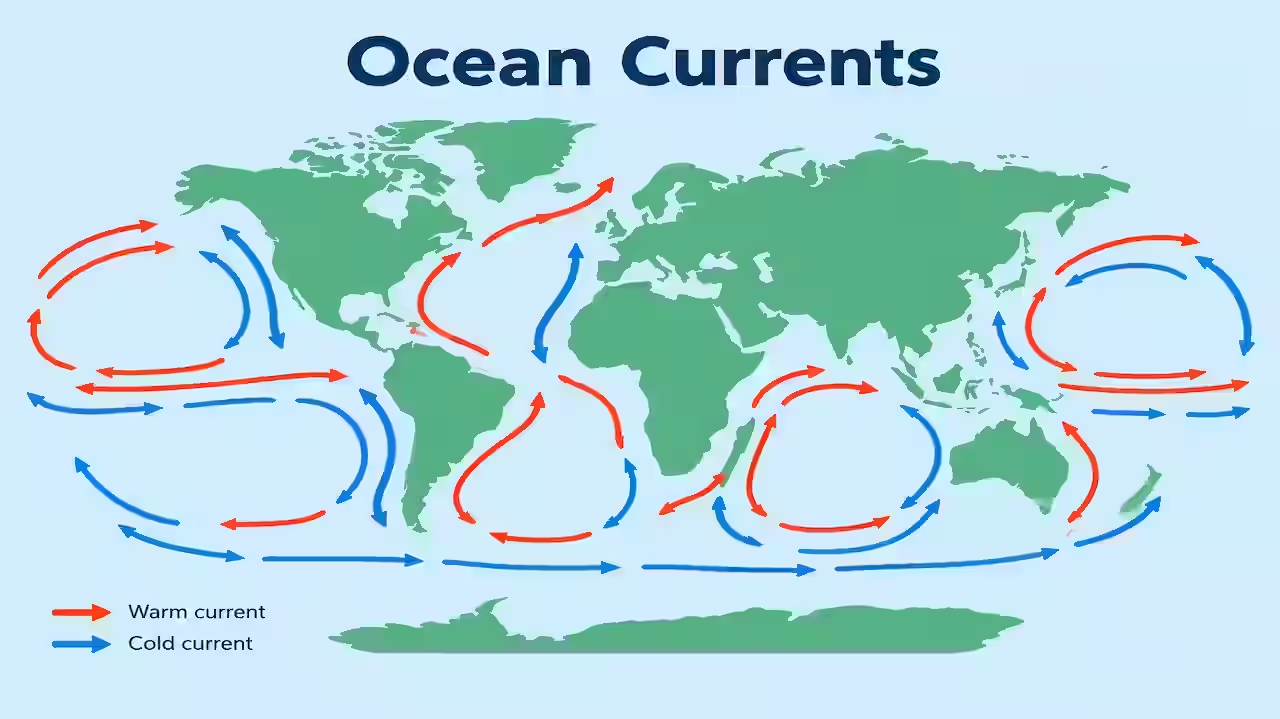
You will get the cause of tides in plain words, the timing rule (why the gap is 12 hours 25 minutes and not 12), a comparison table, Indian examples such as the Gulf of Khambhat and the Hooghly, 14 practice MCQs with explanations, and a quick revision box. If you have read our posts on ocean currents and winds, this chapter is the third piece of the same puzzle: the sea does not move for only one reason.
What Are Tides?
Tides are the regular rise and fall of sea level. Water slowly climbs up the shore, reaches a maximum, then slowly slides back. You can sit on a beach for six hours and watch the whole thing happen.
A few words you must know, because exam options love them:
- High tide (high water): the highest level the sea reaches in one cycle.
- Low tide (low water): the lowest level in that cycle.
- Flood tide: the period when the water is rising and flowing in towards the land.
- Ebb tide: the period when the water is falling and flowing out towards the sea.
- Tidal range: the difference in height between a high tide and the low tide next to it. This is the number that decides whether a tide is called big or small.
Tides are a kind of very long wave, but they are not like the waves you see breaking on the beach. A tide is the whole ocean surface rising and falling slowly, and it is caused by gravity from space, not by wind.
What Causes Tides?
The main cause is the gravitational pull of the Moon. The Sun adds its own, smaller effect. Earth’s spin then carries every coast through the raised water again and again.
The Moon’s pull is uneven
Gravity gets weaker with distance. The sea on the side of Earth facing the Moon is about 6,400 km closer to it than the centre of the Earth is, so it is pulled a little more strongly. The solid Earth’s centre is pulled with medium strength. The sea on the far side is pulled the least.
Picture three students holding hands in a line while the teacher pulls the front one towards the door. The front student is pulled hardest, the middle one less, and the last one is left behind a little. The line stretches. In the same way, the Earth-Moon pull stretches the ocean into a slightly oval shape, with a bulge towards the Moon and another bulge on the opposite side. Each bulge is a high tide. The areas between the bulges have low tide.
Why the Sun matters less than the Moon
Here is a fact that surprises many students. The Sun’s gravity on Earth is much stronger than the Moon’s. Still, the Moon wins the tide contest. The reason is that tides depend on the difference in pull from one side of the Earth to the other, and that difference falls very quickly with distance. The Moon is so near that the difference is large. The Sun is so far that the difference is small. The result: the Sun’s tide-raising effect is only about 46 percent (a little less than half) of the Moon’s.
So the Moon sets the main pattern, and the Sun either helps it or works against it. That helping and fighting is the whole spring and neap story.
Earth’s rotation does the rest
The two bulges stay lined up with the Moon while the Earth spins under them. As your coastline turns into a bulge, you get high tide. As it turns out of the bulge, you get low tide. One full turn passes through both bulges, which is why most coasts see two high tides and two low tides in a day.
Why Two High Tides a Day, and Why 12 Hours 25 Minutes?
Two bulges means two high tides. That part is simple. The timing is where students slip.
The Moon does not stand still. While the Earth spins once, the Moon moves a little ahead in its orbit, in the same direction. So Earth needs extra time to face the Moon again. A place takes 24 hours 50 minutes to come back under the Moon. This is called a lunar day or tidal day. Two high tides fit into it, so the gap between two high tides is half of that: about 12 hours 25 minutes. From high water to the next low water is about 6 hours 12 minutes.
Try a worked example. Suppose high tide at your beach is at 6:00 am on Monday. The next high tide comes at about 6:25 pm. Tuesday’s morning high tide comes at about 6:50 am, which is 50 minutes later than Monday’s. That is why fishermen and port officers always keep a tide table, since the times shift later by roughly 50 minutes every day.
Three types of daily tide pattern
- Semi-diurnal tide: two highs and two lows a day, of nearly equal height. This is the common pattern on many Atlantic coasts.
- Diurnal tide: only one high and one low a day. It is found in a few regions, such as parts of the Gulf of Mexico.
- Mixed tide: two highs and two lows, but the two highs (or two lows) have clearly different heights. Many coasts of the Pacific and parts of India show this mixed behaviour.
So “two tides a day” is the standard rule, but your local pattern depends on the shape of the sea basin. In exams, write the standard rule and add “in most places”.
Spring Tide and Neap Tide: The Core Idea
The Moon goes around the Earth once in about 29.5 days (from one new moon to the next). During this time, the Sun, Earth and Moon change their angle to each other, and the Sun’s pull sometimes adds to the Moon’s and sometimes subtracts.
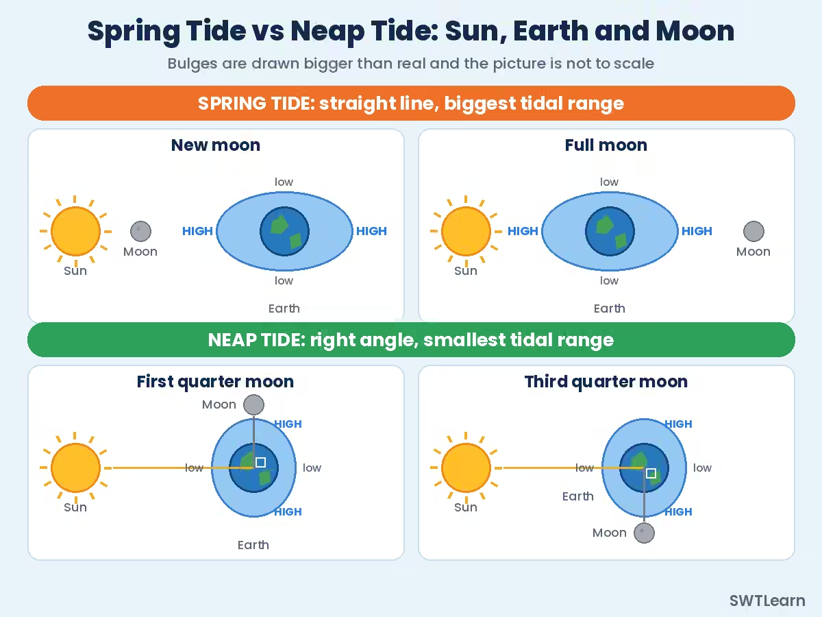
Spring tide: Sun and Moon pull together
At new moon the Moon is between the Sun and the Earth. At full moon the Earth is between the Sun and the Moon. In both cases, the three bodies sit in a straight line. The Sun’s bulge and the Moon’s bulge fall on top of each other, and the ocean is stretched more than usual.
The result: the high tides are higher than average, the low tides are lower than average, and the tidal range is the largest of the month. Spring tides come twice every lunar month, roughly every two weeks.
One warning, and it appears in exams every year: the word “spring” here has nothing to do with the season. It comes from the old idea of the water “springing up”. Spring tides happen in every season.
Neap tide: Sun and Moon pull against each other
About a week after each spring tide, the Moon is at a right angle to the Sun as seen from Earth. This is the first quarter and third quarter moon, when we see a half moon. Now the Sun tries to make a bulge in one direction while the Moon makes it in another. They partly cancel each other.
The result: high tides are lower than average, low tides are higher than average, and the tidal range is the smallest of the month. Neap tides also come twice a month. Sailors sometimes say the sea is “taking a nap”. That is my own memory trick, and it works because neap sounds close to nap.
A month at a glance
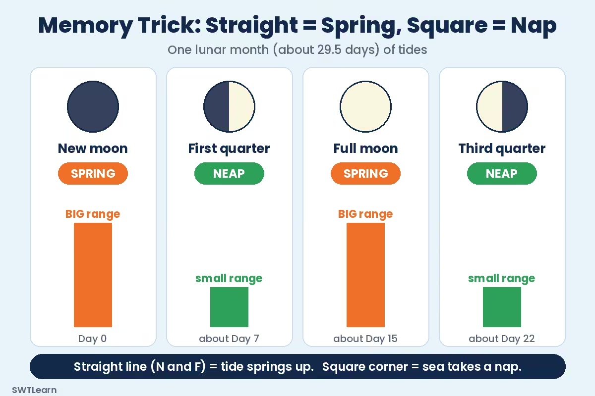
Follow the Moon through one cycle: new moon (spring tide), about 7 days later the first quarter (neap tide), about 7 days after that the full moon (spring tide), and about 7 days later the third quarter (neap tide). Then the new moon returns. Spring to neap to spring to neap, like a slow heartbeat of the sea.
Spring Tide vs Neap Tide: Comparison Table
| Point | Spring tide | Neap tide |
|---|---|---|
| Position of Sun, Earth, Moon | Straight line | Right angle |
| Moon phase | New moon and full moon | First quarter and third quarter |
| Pull of Sun and Moon | Added together | Partly cancel each other |
| High tide | Higher than average | Lower than average |
| Low tide | Lower than average | Higher than average |
| Tidal range | Largest in the month | Smallest in the month |
| Tidal currents | Strongest | Weakest |
| How often | Twice in a lunar month | Twice in a lunar month, about a week after a spring tide |
| Sailors’ view | More water depth at high tide, but strong flow | Calmer flow, less change in depth |
Notice one more detail. A neap tide does not mean “no tide”. The sea still rises and falls. It simply rises and falls by a smaller amount.
My Memory Trick: Straight = Spring, Square = Nap
Here is the trick I give my students. It is only four words, so you can write it on the corner of your rough sheet at the start of the exam.
Straight line = Spring. Square corner = Nap.
- Straight line means Sun, Earth and Moon are in one line. That happens at new moon and full moon. Think “N and F”: New and Full make the sea Full of energy, so the tide springs up.
- Square corner means the Moon makes a right angle with the Sun. That happens at the quarter moons. Neap sounds like nap, so the sea takes a rest.
For the range, keep a one-line picture: “Spring stretches, Neap squeezes”. Two friends pulling a rope the same way move it a long distance. If they pull from different directions, the rope hardly moves.
Perigean and Apogean Tides: When the Moon’s Distance Changes
The Moon’s orbit is not a perfect circle. It is slightly oval. So once every orbit, the Moon is at its closest point to Earth, called perigee. Half an orbit later, it is at its farthest point, called apogee. Remember it like this: peri sounds like “pretty near”, and apo sounds like “a long way off”.
A closer Moon pulls harder, so tides become bigger. When a new or full moon (spring tide) happens near the same time as perigee, you get a perigean spring tide, often called a “king tide” in the news. The US ocean agency NOAA says this happens about 6 to 8 times a year, and that high tides then can be more than a foot (about 30 cm) higher than at an apogean spring tide, depending on the place. When a spring tide happens near apogee, it is a weaker apogean spring tide.
Does a king tide always cause floods? No. The weather also matters. A strong wind pushing water to the coast, or a low-pressure cyclone, can add much more. The Earth’s closeness to the Sun in early January adds only a small extra effect. In the exam, say it simply: a perigean spring tide is the biggest type of regular tide, because Sun, Moon, and Earth are in line and the Moon is closest.
Why Tidal Range Is Different at Different Places
The Moon and the Sun are the same for the whole planet, but the tides are not. The open ocean has a small tide, often around a metre or less. Near coasts the shape of the sea floor and the coastline changes everything.
- Funnel-shaped bays and estuaries squeeze the incoming water into a narrower space, so it piles higher.
- Shallow shelves slow the tidal wave and raise its height.
- Resonance adds more. Every basin has a natural time in which its water sloshes from end to end. If that rhythm matches the tidal rhythm, the tide grows stronger with every swing. Think of carrying a plate of soup. Walk at one particular pace and the soup slops higher with every step. That pace is the natural rhythm of the plate, and a sea basin has a natural rhythm too.
- Enclosed seas such as the Mediterranean get only weak tides because the ocean’s tidal wave cannot enter easily.
Geographers often group tides by range. A common rule is: micro-tidal (less than 2 m), meso-tidal (2 to 4 m) and macro-tidal (more than 4 m). Most exam questions do not ask these terms, but they help you write a better long answer.
Famous High-Tide Places: Bay of Fundy and Indian Coasts
Bay of Fundy, Canada
The Bay of Fundy lies between the Canadian provinces of New Brunswick and Nova Scotia. It has the largest tidal range in the world. At Burntcoat Head in the Minas Basin, the average spring tidal range is about 14.5 metres (a Guinness record), and the highest range ever measured there was about 16.3 metres in 1916. The bay is long and gets narrower and shallower towards its head, and its natural sloshing time is close to the 12 hours 25 minutes tidal rhythm. That match is what makes the tides so big. Roughly 100 billion tonnes of water move in and out each cycle; you will see bigger numbers in tourism pages, so treat all of them as approximate.
For comparison, Tahiti in the middle of the Pacific has almost no tide at all. Same Moon, very different result.
Other places often named for big tides are the Bristol Channel and Severn estuary in the UK and the Mont-Saint-Michel bay in France.
India: where the tide is biggest
India has a long coast, but the tides are very uneven along it. The numbers below come from published studies and differ by site and source, so learn the order and the broad range, not the decimals.
| Region | Approximate tidal range | Why it is known |
|---|---|---|
| Gulf of Khambhat (Cambay), Gujarat | About 5 to 11 m, depending on the site | Highest tides on the Indian coast, ports such as Bhavnagar, biggest tidal energy potential in India |
| Gulf of Kutch, Gujarat | About 4 to 9 m | Kandla (Deendayal) port, second main tidal energy site |
| Hooghly estuary and Sundarbans, West Bengal | About 4 to 7 m | Kolkata and Haldia ports, tidal bore, mangroves |
| Kerala and Karnataka coast | About 1 to 1.5 m | Small tides, backwaters |
| Tamil Nadu coast | About 1 m | Among the smallest tides in India |
So the pattern is: big on the north-west (Gujarat) and north-east (Bengal) corners, small in the south. Both big corners are funnel-shaped gulfs or estuaries, which is the same idea as the Bay of Fundy on a smaller scale.
Tidal Bore: The Wall of Water in the River
A tidal bore is a wave-like front of water that moves up a river against the flow when a high tide enters a narrow, shallow estuary. Instead of a gentle rise, the river level jumps up quickly, sometimes as a single step.
The conditions are: a large tidal range, a funnel-shaped estuary that narrows quickly, and a shallow river bed. Bores are stronger at spring tides than at neap tides, which is another reason to link them with the spring tide in your answer.
- Hooghly River, India: the bore here is known locally as bān (also spelled baan). Port documents describe a bore height up to roughly 2.5 m, travelling at about 30 to 32 km an hour, strongest at spring tides. It can stop work at floating jetties and affect ships.
- Qiantang River, China: one of the best-known bores in the world.
- Amazon River, Brazil: called pororoca locally.
- Severn River, UK and rivers that drain into the Bay of Fundy also have bores.
Tides vs Ocean Currents vs Waves vs Tsunami
This is the section where marks are lost, because all four are “water moving”. Keep the cause in mind and the rest follows.
| Feature | Tide | Ocean current | Wave (wind wave) | Tsunami |
|---|---|---|---|---|
| Main cause | Gravity of Moon and Sun | Winds, Earth’s rotation, density differences | Friction of wind on the surface | Undersea earthquake, landslide or volcanic eruption |
| What happens | Sea level rises and falls | Water flows steadily in one direction over long distances | Surface moves up and down while energy passes through | A series of very long, fast waves that can flood the coast |
| Pattern | Regular, twice a day in most places | Fairly steady, changes seasonally in the north Indian Ocean | Irregular | Sudden and rare |
| Predictable? | Yes, years ahead | Broadly yes | Only short-term forecasts | Not the time of origin |
| Example | Bay of Fundy tides | Gulf Stream, Kuroshio | Surf on a beach | 26 December 2004, Indian Ocean |
Two small notes. First, “tidal wave” is a wrong name for a tsunami. Tsunamis have nothing to do with tides, and scientists avoid the old word. Second, tides do create tidal currents: water flowing in and out of bays and river mouths. These flow for hours and then reverse, unlike the one-way ocean currents in the ocean currents post. If you want the wind side of the story, the winds post explains what makes the surface waves and why a cyclone can raise the sea level even without help from the Moon (that is called a storm surge).
Why Tides Matter: Ports, Fishing and Energy
Ports and ship movement
A big ship needs enough depth under its keel. At a tidal port the depth changes during the day, so captains plan their arrival around high water. Many river ports also use lock gates: they let ships in at high tide and then close the gate, so the water inside the dock stays high even when the river outside falls.
Kolkata is India’s riverine major port, far up the Hooghly, and it depends on the tide to bring ships up the channel. The Haldia dock complex, lower down the river, also uses lock-gated docks. Kandla in the Gulf of Kutch is another port where the large tidal range affects how ships are handled. Port authorities publish tide tables for this purpose (in India, the National Hydrographic Office is the agency that publishes tide tables).
Fishing and coastal life
Small boats in creeks and river mouths often leave and return with the tide. When the tide goes out it exposes mudflats and sandy shores, called the intertidal zone. These are the feeding grounds for birds and crabs, and mangrove forests such as the Sundarbans live in this zone. Tides also push nutrient-rich water in and out of estuaries, which helps fish breeding.
Tidal energy
When the range is large, the rise and fall can turn turbines. A tidal power station often works like a dam across a bay: water enters when the tide rises and flows out through turbines as it falls. Two names to remember:
- La Rance, France: opened in 1966, about 240 MW. For many years it was the largest in the world.
- Sihwa Lake, South Korea: opened in 2011, about 254 MW, now the largest tidal power station.
For India, the commonly quoted potential is about 7,000 MW in the Gulf of Khambhat, about 1,200 MW in the Gulf of Kutch and about 100 MW in the Sundarbans, so “roughly 8,000 MW in all” is how most books round it. A small 3.75 MW demonstration plant at Durgaduani in the Sundarbans was sanctioned in 2008, but the state government later decided not to continue because of the high cost. In 2019 the Government of India declared ocean energy, including tidal energy, as a renewable energy source.
Common Mistakes in Exams
- Spring tide means the season. No. It means the water springs up, and it happens all year.
- Spring tide only at full moon. Wrong. It happens at both new moon and full moon.
- Neap tide means no tide. Wrong. It is the smallest range, with lower high tides and higher low tides.
- Tides come exactly 12 hours apart. They come about 12 hours 25 minutes apart.
- The Sun is the main cause of tides. The Moon is the main cause. The Sun is secondary, about 46 percent of the Moon’s effect.
- Tidal wave = tsunami. No. A tsunami is caused by earthquakes or similar events, not by the Moon.
- Tides and ocean currents are the same. No. Tides are the vertical rise and fall; ocean currents are the horizontal flow of surface water.
- The biggest tide is always at the equator. No. The range depends on the shape of the coast and the sea basin, not on latitude.
What Exam Questions Usually Ask
- Direct fact questions: at which moon phase spring tide occurs; at which phase neap tide occurs; gap between two high tides.
- Match the following: Bay of Fundy with the highest tides; Hooghly with the tidal bore; La Rance with tidal power in France; Khambhat and Kutch with the Indian tidal energy sites.
- Statement questions: “Spring tides occur at the time of full moon and new moon” (true); “Neap tides occur when the Sun and the Moon are in a line” (false).
- Short answers (5 marks): difference between spring and neap tides; causes of tides.
- Long answers (10 to 15 marks): causes, types, importance of tides, with a diagram of Sun, Earth and Moon in both positions.
For any diagram question, draw the Earth, mark the bulges “high tide” on both sides, show the Sun on one side, and label the Moon’s position. A clean sketch like the diagram in this post earns easy marks.
Practice MCQs on Tides
Try all 14 on your own first, then check the answers below.
1. Spring tides occur when:
(a) the Sun, Earth and Moon form a right angle
(b) the Sun, Earth and Moon are in a straight line
(c) the Moon is far from the Earth
(d) it is the spring season
2. Neap tides occur during:
(a) new moon and full moon
(b) solar eclipse only
(c) first quarter and third quarter moon
(d) every night
3. About how much time passes between two successive high tides at the same place?
(a) 6 hours 12 minutes
(b) 12 hours
(c) 12 hours 25 minutes
(d) 24 hours
4. A lunar (tidal) day is about:
(a) 24 hours
(b) 24 hours 50 minutes
(c) 23 hours 56 minutes
(d) 29.5 days
5. Which place has the largest tidal range in the world?
(a) Gulf of Mexico
(b) Mediterranean Sea
(c) Bay of Bengal
(d) Bay of Fundy
6. Which Indian gulf is usually quoted for the largest tidal range and about 7,000 MW of tidal energy potential?
(a) Gulf of Mannar
(b) Gulf of Khambhat
(c) Palk Bay
(d) Gulf of Kutch
7. A tidal bore is well known in which Indian river?
(a) Godavari
(b) Kaveri
(c) Hooghly
(d) Mahanadi
8. A “perigean spring tide” occurs when:
(a) a new or full moon coincides with the Moon being nearest to the Earth
(b) the Moon is farthest from the Earth at first quarter
(c) the Earth is farthest from the Sun
(d) there is a tsunami

9. The Sun’s tide-producing effect compared with the Moon’s is:
(a) about equal
(b) about twice as much
(c) a little less than half
(d) about ten times as much
10. Why is the neap tidal range the smallest?
(a) The Moon is absent
(b) The Sun’s and the Moon’s pulls partly cancel each other
(c) The Earth stops rotating
(d) Winds blow in the opposite direction
11. The water flowing towards the land during rising tide is called:
(a) ebb tide
(b) flood tide
(c) neap tide
(d) slack tide
12. The first large tidal power station of the world, opened in 1966, is at:
(a) Sihwa Lake
(b) Bay of Fundy
(c) La Rance
(d) Durgaduani
13. Which statement about tsunami is correct?
(a) It is caused by the Moon
(b) It occurs only at full moon
(c) It is a “tidal wave” caused by spring tides
(d) It is usually caused by an undersea earthquake, landslide or volcanic eruption
14. How many spring tides occur in one lunar month (about 29.5 days)?
(a) One
(b) Two
(c) Four
(d) Seven
Answers and Explanations
1. (b) A straight line makes the Sun and the Moon pull together. “Spring” has nothing to do with the season.
2. (c) At the quarter moons the Moon is at a right angle to the Sun, and the two pulls partly cancel.
3. (c) The lunar day is 24 h 50 min and holds two high tides, so each gap is about 12 h 25 min.
4. (b) The Moon moves ahead in its orbit, so Earth needs about 50 extra minutes to face it again. (23 h 56 min is the time of one Earth rotation, a different thing.)
5. (d) The Bay of Fundy, Canada, with a range of about 16 m at its head. The mean spring range at Burntcoat Head is about 14.5 m.
6. (b) The Gulf of Khambhat (Cambay) in Gujarat. The Gulf of Kutch is next, with about 1,200 MW.
7. (c) The Hooghly bore (bān) is strongest at spring tides.
8. (a) Perigee means the Moon is closest. A spring tide near perigee is the strongest regular tide, popularly called a king tide.
9. (c) The Sun’s tide-raising force is about 46 percent of the Moon’s, so it is a little less than half.
10. (b) With the Sun and Moon at right angles, their bulges partly cancel, and the range is smallest.
11. (b) Flood tide is the rising, incoming water. The falling, outgoing water is the ebb tide.
12. (c) La Rance in France (about 240 MW). Sihwa Lake in South Korea came much later, in 2011.
13. (d) A tsunami is a seismic or landslide wave. It is not connected with the tides, and “tidal wave” is a wrong name for it.
14. (b) One at new moon and one at full moon. The neap tides also come twice.
Quick Revision Box
- Cause: gravity of the Moon (main) and the Sun (about 46 percent of the Moon’s effect). Two bulges, so two high tides a day in most places.
- Timing: lunar day 24 h 50 min; high tides about 12 h 25 min apart; tides come about 50 minutes later every day.
- Spring tide: new moon and full moon, straight line, largest range, twice a month.
- Neap tide: first and third quarter, right angle, smallest range, about 7 days after a spring tide.
- Trick: Straight line = Spring. Square corner = Nap.
- Perigee (Moon nearest) + spring tide = perigean spring tide (king tide).
- Highest tides: Bay of Fundy (about 16 m at the top of the range). Tahiti has almost none.
- India: Khambhat greatest, then Kutch, then Hooghly and Sundarbans. South coast has small tides (1 to 1.5 m).
- Tidal bore: Hooghly (bān), Qiantang, Amazon (pororoca).
- Tidal power: La Rance (France, 1966), Sihwa Lake (South Korea, 2011). India’s potential: about 8,000 MW.
- Not the same: tides, ocean currents, waves and tsunami. “Tidal wave” is not a tsunami.
Conclusion
Tides look complicated until you separate three things: the Moon makes two bulges, the Earth’s spin carries you through them, and the Sun either adds to or reduces the effect depending on the angle. After that, every fact in this chapter hangs on that frame: spring and neap, perigee and apogee, the Bay of Fundy and the Gulf of Khambhat, the Hooghly bore and the tidal power plants.
Revise the spring tide and neap tide table, repeat “straight line is spring, square corner is nap” a few times, and try the MCQs again after two days without looking at the answers. If you want daily GK tricks and quizzes like this one, join the SWTLearn Telegram group and tell us which topic you want next.
FAQs
Q1. What is the main difference between spring tide and neap tide?
A: A spring tide happens at new moon and full moon, when the Sun, Moon and Earth are in a line, and it gives the highest high tides and lowest low tides. A neap tide happens at the quarter moons, when the Sun and Moon pull at a right angle, and it gives the smallest tidal range.
Q2. Why are there two high tides every day?
A: The Moon’s pull makes two bulges of water on the Earth, one facing the Moon and one on the opposite side. As the Earth rotates, a coast passes through both bulges, so most places get two high tides and two low tides in about 24 hours 50 minutes.
Q3. Why does the high tide time change every day?
A: The Moon moves forward in its orbit while the Earth rotates, so the Earth takes about 50 minutes extra to face the Moon again. This is why tides arrive about 50 minutes later each day.
Q4. Which place has the highest tides in the world?
A: The Bay of Fundy in Canada. At Burntcoat Head the average spring range is about 14.5 metres and the highest recorded range is about 16.3 metres. The long, narrowing shape of the bay and its natural rhythm, which matches the tidal rhythm, make the tide so large.
Q5. Is a tidal wave the same as a tsunami?
A: No. Tides are caused by the gravity of the Moon and the Sun. A tsunami is usually caused by an undersea earthquake, landslide or volcanic eruption. The name “tidal wave” is misleading and should not be used for a tsunami.
Q6. Which Indian coasts have the biggest tides and why?
A: The Gulf of Khambhat and the Gulf of Kutch in Gujarat, and the Hooghly estuary and Sundarbans in West Bengal. All of them are funnel-shaped gulfs or estuaries on shallow coasts, so the incoming tide is squeezed and rises higher. The south Indian coast has much smaller tides.